


Mr. Philip D. Burden
P.O. Box 863,
Chalfont St. Giles, Bucks HP6 9HD,
UNITED KINGDOM
Tel: +44 (0) 1494 76 33 13
Email: enquiries@caburden.com
64 rare maps matched your search criteria.
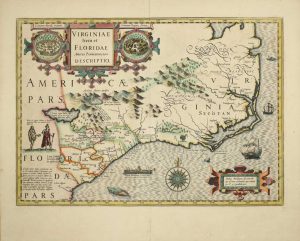
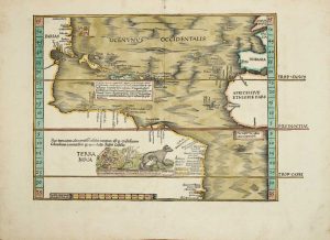
Theodore de Bry, Frankfurt, 1590
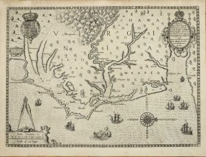
305 x 415 mm., with good margins in good condition.
Stock number: 8221
$ 18,500
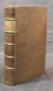
Chez Abraham Wolfgang, pres la Bourse, Amsterdam, 1688
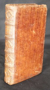
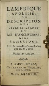
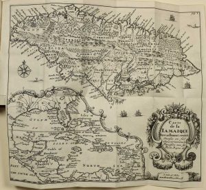
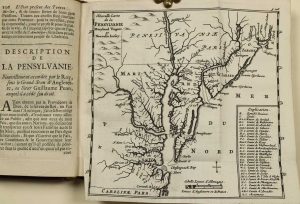
WITH A PREVIOUSLY UNRECORDED FIRST STATE OF THE MAP OF NEW ENGLAND. Duodecimo (150 x 85 mm.), full contemporary calf, blind panelled, with ribbed spine, very ornate gilt decoration to compartments, gilt title, gilt slightly worn. With typographic title page, pp. [4], 331, [1], p. 236 erroneously numbered 136, with 7 folding maps, otherwise in excellent condition.
Stock number: 9894
$ 4,950
Philadelphia, 1792
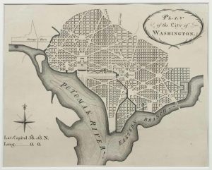
PRESENTATION COPY OF THE FIRST PLAN OF WASHINGTON. 220 x 265 mm., uncut, in very good condition.
Stock number: 8229
$ 25,000
Drawn and Engrav'd for D. Longworth Map & Print Seller No.66 Nassau Street, New York, c.1796-[c.98]
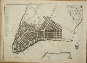
A PRESENTATION COPY OF THE FIRST FOLIO PLAN OF NEW YORK. 410 x 555 mm., with light offsetting, good margins, uncut, with manuscript title to the verso, in good condition.
Stock number: 9726
$ 37,500
(Printed by Samuel Loudon, No. 5, Water-Street, between the Coffee-House and Old Slip), New York, 24 November 1783
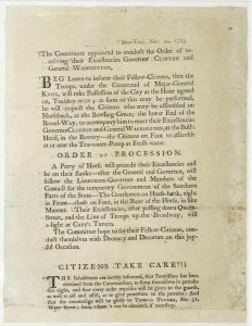
BROADSIDE POSTED IN NEW YORK DETAILING THE PROCESSION TO RE-OCCUPY THE CITY. 270 x 155 mm., professionally lined with tissue, with loss of the last five lines and imprint, otherwise in good condition.
Stock number: 9727
$ 49,500
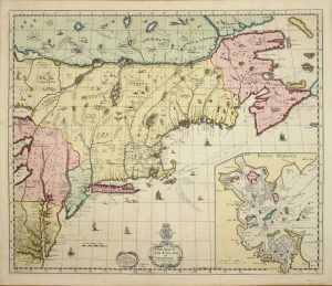
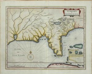
London, 1624
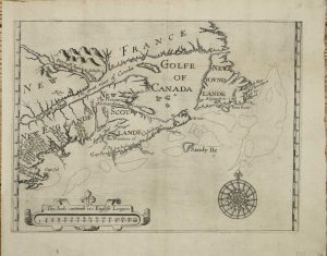
AN EXCEEDINGLY RARE MAP in its FIRST STATE. 250 x 340 mm., with wide margins, with some repair to double folds as might be expected, light fold along the centre, otherwise in good condition.
Stock number: 9881
$ 15,950
C. Browne at the North gate of the Royal Exchange & by him at the Globe by the West end of St. Paul's Church, London, 1712
BEAUTIFUL EARLY WASH COLOUR. 500 x 595 mm., in magnificent full early wash colour, good condition.
Stock number: 8247
$ 49,500
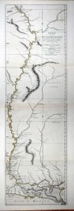
London, 5 August 1775
![[Chart of the Harbour of Boston]/ Nautical Remarks and Observations for the Chart of the Harbour of Boston. Composed from different Surveys; but principally from that taken in 1769, by George Callendar, Late Master of His Majesty's Ship the Romney.](https://www.caburdenraremaps.com/wp-content/uploads/2022/01/8314a-300x213.jpg)
![[Chart of the Harbour of Boston]/ Nautical Remarks and Observations for the Chart of the Harbour of Boston. Composed from different Surveys; but principally from that taken in 1769, by George Callendar, Late Master of His Majesty's Ship the Romney.](https://www.caburdenraremaps.com/wp-content/uploads/2022/01/8314b-233x300.jpg)
![[Chart of the Harbour of Boston]/ Nautical Remarks and Observations for the Chart of the Harbour of Boston. Composed from different Surveys; but principally from that taken in 1769, by George Callendar, Late Master of His Majesty's Ship the Romney.](https://www.caburdenraremaps.com/wp-content/uploads/2022/01/8314c-246x300.jpg)
FIRST STATE. ACQUIRED BY HUGH PERCY, THE SAVIOUR OF THE BRITISH AT LEXINGTON AND CONCORD. 705 x 1040 mm., in 2 sheets joined, large aquatint and etched engraving, UNFOLDED AND UNCUT, with the LVG watermark. With pamphlet, quarto (280 x 230 mm.), original blue wrappers, typographic title, pp. 5-(12), there are no pages 3-4 which agrees with the John Carter Brown example.
Stock number: 8314
$ 22,500
Amsterdam, 1606-[19]
350 x 490 mm., early wash colour with French text, in good condition.
Stock number: 9123
$ 3,500
Venice, 1528-[47]
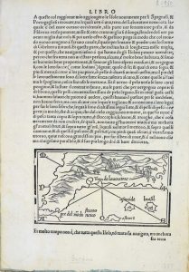
85 x 145 mm., small area of margin loss repaired in far upper right margin level with the text, otherwise good condition.
Stock number: 5237
$ 1,950
Leiden, 1630
275 x 350 mm., in recent wash colour, good condition.
Stock number: 6044
$ 3,950
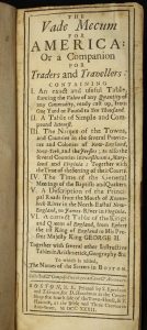
John Stockdale, London, 1792
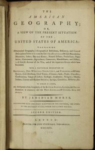
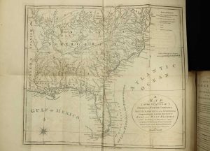
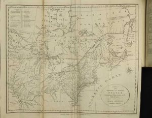
Octavo (220 x 145 mm.), full modern calf, gilt ruled ribbed spine with calf gilt title label, pp. xvi, 536. With two large folding maps and a folding table, in good condition.
Stock number: 7142
$ 1,250
Madrid, 1601
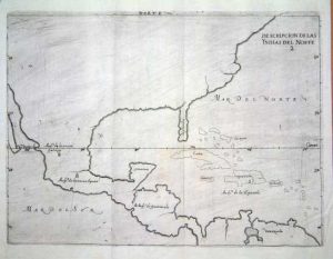
215 x 280 mm., in good condition.
Stock number: 6446
$ 1,950
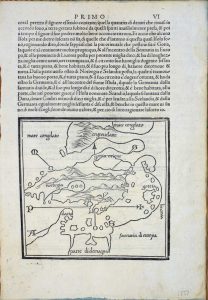
Strasbourg, 1522-[25]
290 x 380 mm., in FULL EARLY WASH COLOUR, in good condition.
Stock number: 8220
$ 19,500
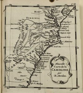
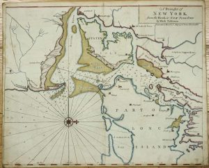
Iohn Thornton at ye Platt in ye Minories./ By Robt. Morden at the Atlas in Corn-hill./ And by Phillip Lea at ye Atlas & Herculus/ in the Poultry, London, c.1685
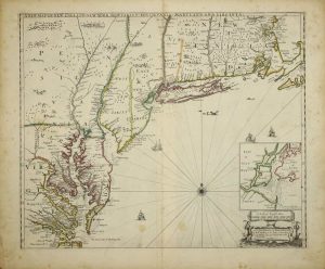
The FIRST STATE in fine EARLY OUTLINE COLOUR of the FIRST PLAN OF NEW YORK HARBOUR. 450 x 550 mm., in early outline colour, with two marks lower centre, otherwise in good condition.
Stock number: 8223
$ 29,500
I. Mount & T. Page upon Tower Hill, London, 1732-[73]
460 x 570 mm., in recent outline and wash colour, with margin's all round, slim on the lower and lower left, light offsetting and foxing otherwise in good condition.
Stock number: 8225
$ 3,950
Paris, 1821
390 x 250 mm., early outline colour.
Stock number: 8820
$ 375
Printed by S. Kneeland and T. Green for D. Hencilman at the Corner Shop, the South Side of the Town-House & T. Hancock at the Bible and Three Crowns in Ann-Street, Boston, 1732
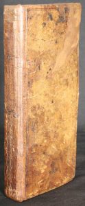
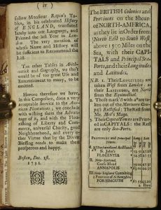
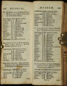
Tall 16mo (180 x 75 mm.), full contemporary calf, blind panelled, rebacked preserving original spine with blind ruled compartments. [2], vi, 220 pp., later endpapers, some occasional light foxing otherwise in good condition.
Stock number: 8909
$ 2,950
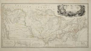
Robert Sayer, London, 1772-[75]
FIRST LARGE SCALE ENGLISH MAP OF THE REGION AFTER THE TREATY. 1120 x 340 mm., in fine early outline colour. Two sheets joined, printed on strong paper, in good condition.
Stock number: 8848
$ 5,500
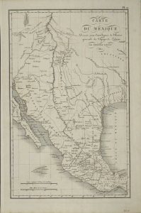
Paris, 1839
415 x 810 mm., large folding map in early outline colour as issued, one or two light creases, some browning to upper margin and water stain to lower margins not affecting the map, otherwise in good condition with no major splits or tears.
Stock number: 8228
$ 6,950