


Mr. Philip D. Burden
P.O. Box 863,
Chalfont St. Giles, Bucks HP6 9HD,
UNITED KINGDOM
Tel: +44 (0) 1494 76 33 13
Email: enquiries@caburden.com
61 rare maps matched your search criteria.
(Chicago?), c.1830
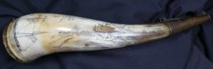
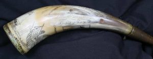
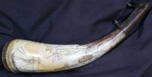
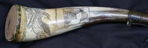
AN ORIGINAL POWDER HORN WITH THE SECOND EARLIEST KNOWN VIEW OF FORT DEARBORN (CHICAGO). An engraved or scrimshawed cow horn using a burin, 26 centimetres (10.5 inches) long with a maximum circumference of 15 cms., with a cork plug at the base secured by four brass pins, one is missing, the spout is capped with a later brass sprung cap with a ring for a strap and was worn on the right-hand side.
Stock number: 11029
$ 150,000
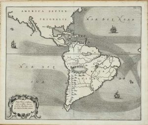
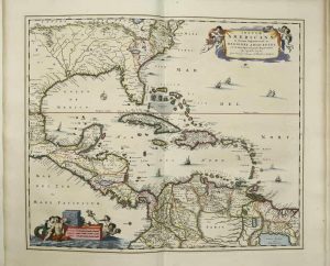
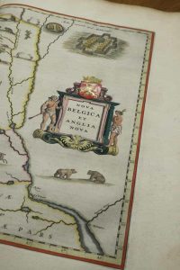
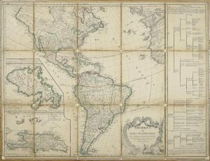
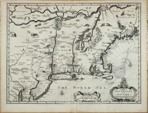
Amsterdam, 1730-[c.55]
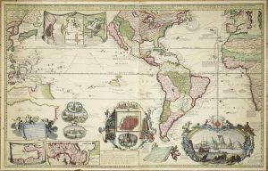
590 x 940 mm., in fine early wash colour, some light restoration to folds at the centre, otherwise in good condition.
Stock number: 11138
$ 19,500
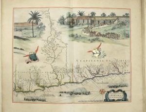
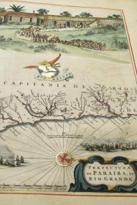
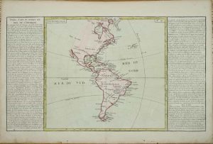
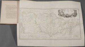
Paris, 1713
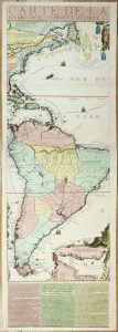
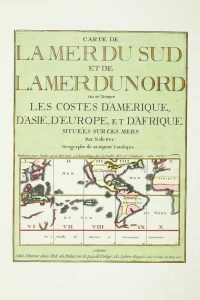
1175 x 380 mm., full early wash colour, with accompanying title page included a key map, bookplate of the Duke of York on the verso, in very good condition.
Stock number: 11134
$ 13,500
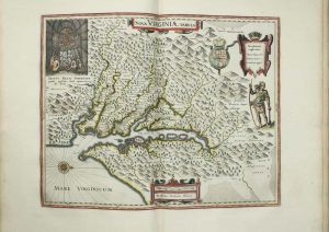
George Humble, London, 1627-[31]
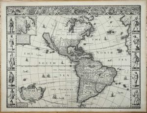
FIRST ATLAS MAP TO DEPICT CALIFORNIA AS AN ISLAND. 390 x 510 mm., with a wormhole near the bottom of the centrefold repaired, otherwise in good condition.
Stock number: 11106
$ 4,500
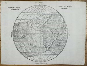
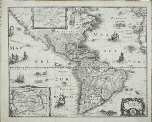
Amsterdam, 1665
340 x 410 mm. with light toning at margin edges, otherwise in good condition.
Stock number: 11118
$ 995
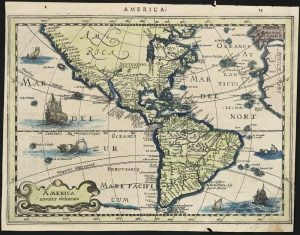
Venice, 1565
300 x 330 mm., woodcut engraving, with very minor edge repair at upper and lower centrefolds, otherwise in good condition.
Stock number: 11098
$ 5,000
Printed, Colered, and are/ to be sold by Ro:Walton/ at ye Globe and Compass in St. Paules Church yard between/ ye two north doores, London, 1658-[c.60]
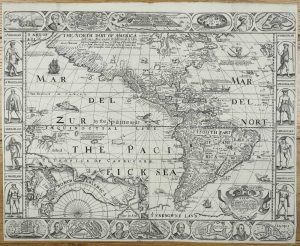
420 x 530 mm., minute area of loss at double fold as expected, otherwise in good condition.
Stock number: 11116
$ 12,500
Ioannis Blaeu, Amsterdam, 1662
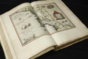
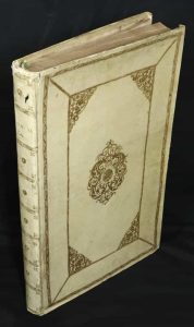
HIGHLIGHTED IN GOLD, EXTRA-ILLUSTRATED. Large folio (560 x 360 mm.), contemporary Dutch yap vellum with gilt panels, central ornate design with decorative corners, with ornate gilt spines, upper edge of spine worn, lacking cloth ties. Typographic title page with central vignette, Latin text, paginated 1-287, (2), with 24 maps all coloured in a fine contemporary hand with gold touches (extra illustrated with a Visscher map of the West Indies), some toning and foxing mostly to some of the text, otherwise a very good example.
Stock number: 11082
$ 95,000
Antwerp, 1567
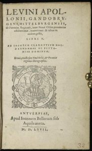
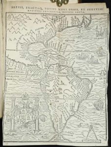
Octavo (160 x 105 mm.), contemporary vellum yap binding, red gilt calf title label affixed to spine. Typographic title with device, pagination of the leaves only 236, (8), and a folding woodcut map, i very good condition.
Stock number: 11079
$ 17,500
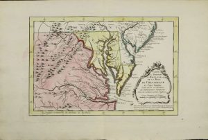
Paris, 1778
500 x 660 mm., dissected and laid on contemporary linen, laid down on board, early outline colour, some loss of cloth at folds, the folded cloth over the edges masks the scales which appear below the margins, light surface wear.
Stock number: 11148
$ 350
Paris, 1780
315 x 550 mm, including the side panels, early wash colour, very small worm hole in the centre, otherwise in good condition.
Stock number: 11150
$ 175
Amsterdam, 1630-[32]
195 x 255 mm., with recent wash colour, light even toning, margins trimmed slightly, centrefold crease, verso with remnants of old guard remaining, otherwise in good condition.
Stock number: 11107
$ 495
Frankfurt, 1631
355 x 445 mm., with professional repair to a tear in the upper margin just left of centre, otherwise in good condition.
Stock number: 11109
$ 850
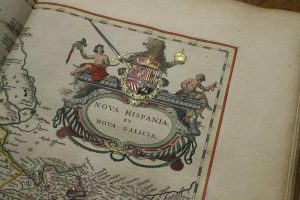
John Melish, Philadelphia, 6th day of June 1816
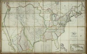
MANIFEST DESTINY, FIRST EDITION, FOURTH ISSUE. 885 x 1440 mm., copper engraved map on six sheets, laid on contemporary linen, edged in silk, cut and dissected, early outline colour, marbled endpapers, in good condition.
Stock number: 11012
$ 69,500
Cadell & Davies & Longman, Hurst, Rees, Orme & Brown, London, 1809-[15]
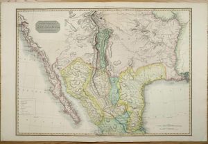
515 x 705 mm., lovely early wash colour, in good condition.
Stock number: 10940
$ 1,350
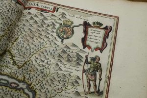
London, c.1673
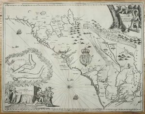
THE FIRST LORDS PROPRIETORS MAP. 420 x 550 mm., with a couple of very minor splits along the folds professionally repaired, trimmed close as usual, otherwise in very good condition.
Stock number: 10953
$ 15,000
Sold by Tho:Bassett in Fleetstreet and Richard Chiswell in St. Pauls Church Yard, London, 1676
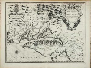
380 x 500 mm., with a small upper right corner margin repair, otherwise in good condition.
Stock number: 10915
$ 4,500
Sold by Tho:Bassett in Fleetstreet and Richard Chiswell in St. Pauls Church Yard, London, 1676
380 x 505 mm., in good condition.
Stock number: 10914
$ 5,500
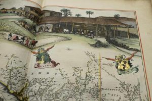
J. Hoelscher, Coblenz, 1839-41
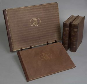
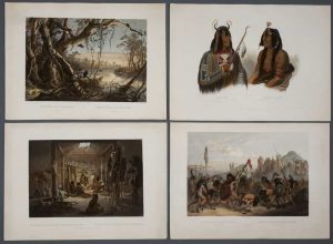
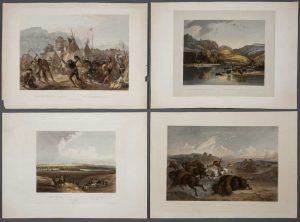
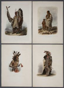
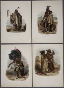
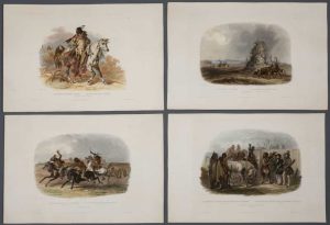
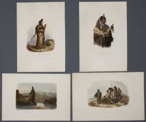
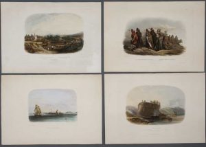
FIRST EDITION IN COLOUR. Text in two large quarto volumes (330 x 280 mm. ea.), recent matching half calf, brown moiré cloth boards, spines with gilt ruled raised bands with gilt titles, with central blind embossed compartments. With titles, half-titles, table of contents, list of subscribers, pp. [16], 654, [2]; [24], 688, [2], containing over 40 woodblock engravings set within the text, with the large folding map (415 x 810 mm.) in early outline colour often missing. Tableau atlas in oblong portfolio (430 x 610 mm.), in contemporary half calf binding, brown moiré cloth boards, gilt panelled with central gilt title within ornate frame, spine with gilt ruled raised bands, compartments with ornate blind central feature, interior of both boards with publisher's green moiré paper, extremities lightly rubbed. Containing 48 plates consisting of 48 Tableau engravings on steel and copper in excellent old colour heightened with gum Arabic and a table illustrating the temperatures at Fort Union and Fort Clark (often lacking), 41 plates in their first state, the remainder early states, minor repairs, none affecting plate area, with protective tissue, all with publisher's blind stamp. Vignette atlas in oblong portfolio (330 x 485 mm.), in contemporary half calf binding, brown moiré cloth boards, gilt panelled with central gilt title within ornate frame, rebacked to style, interior of both boards with publisher's green moiré paper. Containing 33 Vignette engravings on steel and copper in excellent old colour heightened with gum Arabic, 30 plates in their first state, the remainder early states, minor repairs, none affecting plate area, with protective tissue, all with publisher's blind stamp.
Stock number: 10823
$ 750,000
Ernest van Harrevelt; Daniel Jean Changuion, Amsterdam, 1773
200 x 290 mm., in very nice full early wash colour, good condition.
Stock number: 10803
$ 450